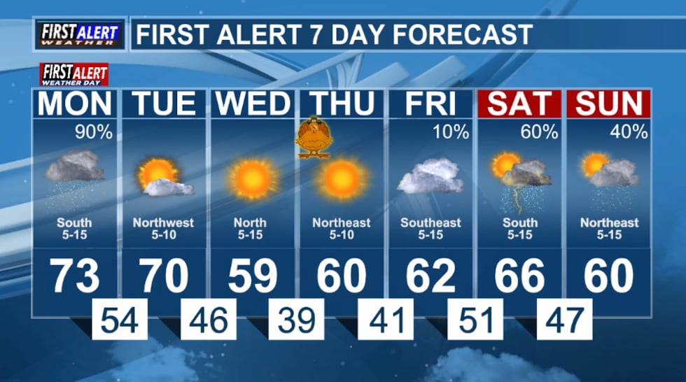
First Alert Weather Day: Monday

East Texas Braces for Thanksgiving Week Storms, Potential Flooding
TYLER, Texas – East Texas residents are preparing for a soggy start to the Thanksgiving holiday week as a potent weather system moves into the region. A First Alert Weather Day has been declared for Monday, November 24, 2025, with forecasts predicting showers and thunderstorms increasing throughout the day. The potential for localized flooding and severe weather is prompting officials to urge caution, especially for those planning travel.
A Week Already Saturated
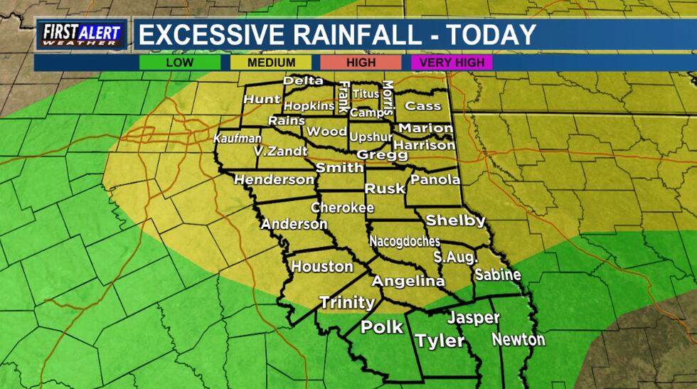
The incoming rainfall is compounding an already wet situation across East Texas. Recent days have seen significant precipitation, leaving the ground saturated and increasing the risk of rapid runoff. The National Weather Service predicts an additional 1-2 inches of rain, potentially leading to water ponding on roadways and, more seriously, localized flooding. The northern half of East Texas is considered particularly vulnerable.
(KLTV)
Severe Threat Looms
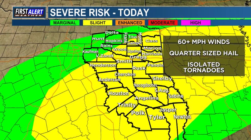
Beyond the flooding concerns, the Storm Prediction Center has issued a Slight Risk (Level 2/5) for severe thunderstorms across most of East Texas. The threat begins Monday morning, with the possibility of strong winds and hail the size of dimes and quarters. However, the most significant risk for severe weather will develop during the afternoon and evening.
Forecasters warn that conditions are favorable for strong, damaging winds, large hail, and even a few tornadoes. Residents are advised to stay informed and have a plan in place should warnings be issued. Local news stations, including KLTV and KTRE, will provide continuous updates throughout the day.
Thanksgiving Travel Complications
The timing of this weather event is particularly problematic, falling at the beginning of one of the busiest travel weeks of the year. The Transportation Security Administration (TSA) anticipates record-breaking passenger volumes this Thanksgiving, and the severe weather could lead to significant delays at airports and on roadways.
“We’re urging travelers to check their flight status before heading to the airport and to allow extra time for their journey,” said a spokesperson for the Texas Department of Transportation. “If possible, consider delaying travel until conditions improve.”
(KLTV)
A Global Pattern of Extreme Weather
This weather event in East Texas is part of a larger global pattern of increasingly frequent and intense extreme weather events. According to the United Nations Framework Convention on Climate Change, the past decade was the warmest on record, and the trend is expected to continue. In 2023 alone, extreme weather events caused an estimated $115 billion in economic losses globally – a figure that underscores the growing cost of climate change.
“We are seeing a clear link between climate change and the increasing frequency and intensity of extreme weather events,” says Dr. Emily Carter, a climate scientist at the University of Texas at Austin. “Warmer temperatures lead to more moisture in the atmosphere, which fuels heavier rainfall and more severe storms.”
(KLTV)
Residents are encouraged to stay tuned to local news sources for the latest updates and to heed any warnings issued by local authorities. Preparation and awareness are key to staying safe during this potentially dangerous weather event.
ARTICOL ORIGINAL:
EAST TEXAS (KLTV/KTRE) – Monday, November 24, 2025, has been declared a First Alert Weather Day.
Below is the livestream of East Texas Now. Between weather updates, you’ll find live, local news coverage from the East Texas newsroom.
Showers and thunderstorms will return to East Texas this morning and will increase in coverage through the day. An additional 1-2 inches of rain appear likely on top of what has already fallen in recent days. Heavy rain will create concern for water ponding on roads for those traveling as the Thanksgiving week begins. Additionally, localized flooding will be possible, especially for the northern half of East Texas, so it would be best to avoid flood-prone areas.
The Storm Prediction Center has also placed most of the East Texas area under a Slight Risk (Level 2/5) for strong to severe thunderstorms. A few stronger storms capable of gusty winds and dime-quarter sized hail will be possible as early as Monday morning, but the threat for strong to severe thunderstorms will be greatest during the afternoon and evening hours. Strong winds, large hail, and a few tornadoes will be possible. Stay tuned to KLTV and KTRE for the latest updates.
Copyright 2025 KLTV/KTRE. All rights reserved.